Arrival at Ulm University

Ulm - situated in the eastern part of Baden-Württemberg at the border to Bavaria - is easy to get to and very well connected to the transportation infrastructure. Several motorways (Autobahnen) and highways (Bundesstraßen) pass through Ulm or run directly past it. Numerous railway lines (Eisenbahnlinien) meet in Ulm - e.g. the high-speed train (ICE) Stuttgart - Munich, which is part of the main European traffic artery Paris - Budapest. The major airports Stuttgart, Munich and Frankfurt are easily reachable by train. There are closer regional airports in Memmingen and Friedrichshafen that are serviced regularly by public transport.

Details on transport connections

A7Flensburg - Hamburg - Hannover - Kassel - Fulda - Würzburg - Ulm - Memmingen - Kempten - Füssen/Reutte (Tirol)
A8Karlsruhe - Stuttgart - Ulm - Augsburg - München - Salzburg
B10Pirmasens - Karlsruhe - Stuttgart - Ulm/Neu-Ulm - Nersingen (- Augsburg)
B19Eisennach - Würzburg - Ulm/Neu-Ulm - Kempten - Oberstdorf
B28Strasbourg - Freudenstadt - Tübingen - Reutlingen - Ulm
B30Ulm - Biberach (Riß) - Ravensburg - Friedrichshafen
B311Ulm - Ehingen - Tuttlingen - Geisingen (-Donaueschingen)
Source: Wikipedia

Europa-Magistrale
Main European traffic artery
Paris - ... - Stuttgart - Ulm - Augsburg - München - ... Budapest
Filstalbahn
Filstal line
Ulm - Geislingen - Göppingen - Plochingen - Stuttgart
Württembergische Südbahn
Southern line of Baden-Württemberg
Ulm - Biberach (Riß) Aulendorf - Ravensburg - Friedrichshafen
Donautalbahn
Danube Valley line
Donaueschingen - Tuttlingen - Sigmaringen - Ehingen (Donau) Ulm - Donauwörth - Ingolsstadt - Regensburg
Illertalbahn
Iller Valley line
Ulm - Memmingen - Kempten - Oberstdorf
Brenzbahn
Brenz line
Ulm - Heidenheim - Aalen (- Ellwangen - Crailsheim)
Source: Wikipedia

Distance to UlmTravel time of
quickest train connection
Frankfurt - FRA
ca. 280 kmca.  2  1/4 h
München - MUC
ca. 160 kmca.  2  1/4 h
Stuttgart - STR
ca. 80 kmca.  1  3/4 h
Friedrichshafen - FDH
ca. 100 kmca.  1 h
Memmingen - FMM
ca. 60 kmca.  1 h

Public transport to the campus

  • With the free DING-App for iPhone und android you can check the departure time of all lines at individual stops

Tram line 2 and bus line 5 both connect the main station with the campus.

  • Travel time is approx. 10 to 20 minutes. Your concrete destination on the ca. 1.5 km long campus determines which of the 5 stops is best for you, and thus your travel time.
  • Both lines serve all stops.
  • Both lines run every 10 minutes on workdays; during lecture periods tram line 2 even runs every 3-5 minutes during peak hours.

Overview of the various stops at the main station (download)

  • Here you can download the SWU network map and other schedules.
  • The lines 2, 5, 8, 13 and 15 all serve the various stops at the University. There are different options depending on which suburb you are in.
  • If none of those lines stop close to where you are, it might be best to take the line closest to you till main station and then change to tram line 2 or bus line 5.

  • Line 2
    Kuhberg - Science Park II
     
  • Line 5
    Ludwigsfeld/Wiley - Wissenschaft
     
  • Line 8
    Gimmelfingen - Uni Süd
     
  • Line 13
    Im Lehrer Feld - Botanischer Garten
     
  • Line 15
    Williy-Brandt-Platz - Science Park III

For up-to-date information go to the DING-semester ticket web page.
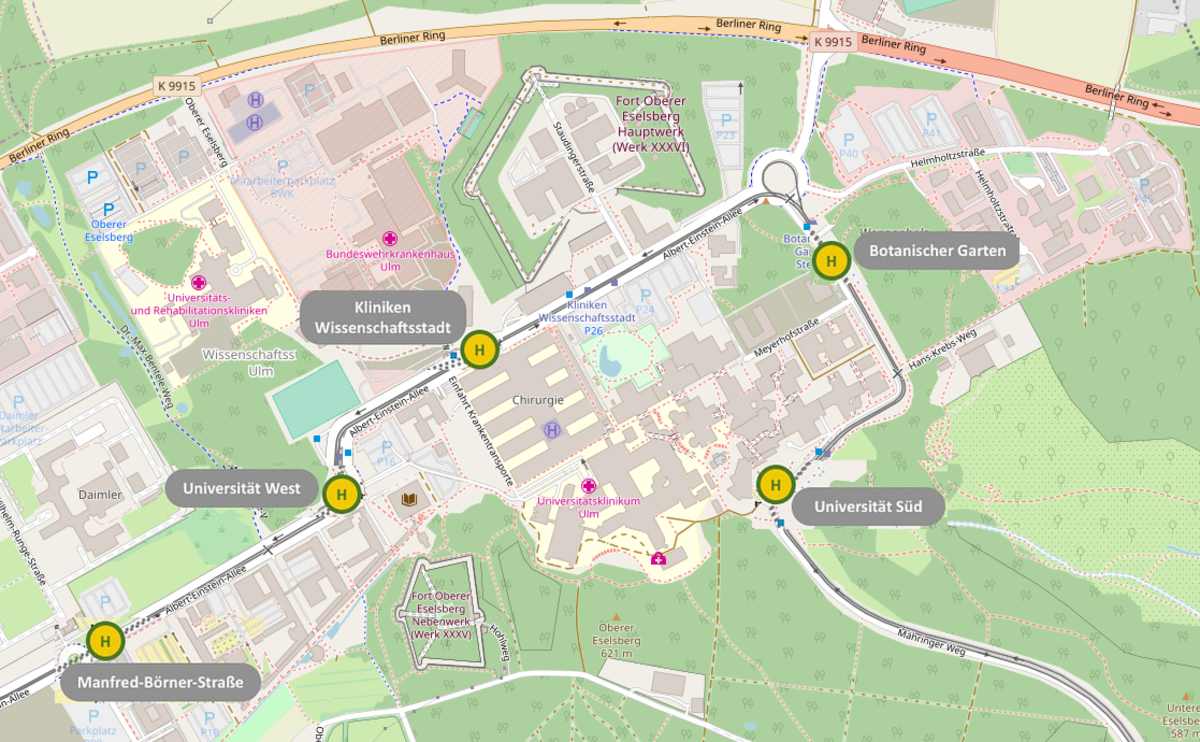
Stops on campus
Stops on campus | Map © OpenStreetMap contributors
Name of the stop*Approximate target area on campus
Universität SüdUni East | South entrance
Botanischer GartenUni-East | access areas from East;
University Administration; Botanical Garden
Kliniken Wissenschaftsstadtuniversity hospital, military hospital (BWK), rehabilitation hospital (RKU)
Universität WestUni West | Albert-Einstein-Allee 37 to 43
Manfred-Börner-StraßeUni West | Albert-Einstein-Allee 43 to 47
*linked to OSM